
![]() GEOGRAPHY
GEOGRAPHY
SUMIDOURO![]()
![]()
![]()
![]()
![]()
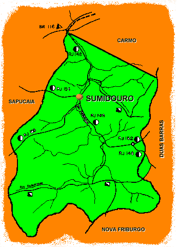
Sumidouro's map (click on the commune's map to have the downtown's map).
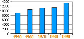
The graphic above shows the Sumidouro's population evolution between 1950 and 1990. Compared to the State's population which increased three times in the same period, or to the mountain-region population which has grown about 65%, we may almost say that Sumidouro knows a demographic stagnation.
The topography is mountainous and the land is covered mainly by grass. The clearing of the forest for the coffee's culture in the last century and the lack of a forest policy acceletated the process of soil erosion. 34,5% of it has an orange color and 4,6% a red color (two kinds of Latosol), and the rest is a mixture of latosol and podzolic soil with low level of humus and high acidity ( wich demands a systematical correction of the pH for agricultural use).
The climate is typically of tropical hyghlands : an average temperature of 21°C and 1.430,7 mm rainfall by year. The most important river is the Paquequer which receives along it's way from south to north the waters of litle streams like Lambari, São Lourenço, Campulose etc. The topography allows somme falls like Ponte do Amaro and Figueiras, Conde D’Eu (127 m !), and somme rapids like Lambari.
The DRM-RJ (State Mineral Ressources Dept.) reports the existence of mineralwater sources, caulim, feldspat and mica, but any economic explotation is engaged.
Some hamlets like Campinas, Dona Mariana, Barra de São Francisco and Murinelli houses the rest of the " urban " population. Sumidouro has a particularity : the population ratio "urban/country" is the oposite of the State of Rio : about 10% for country population in the state, 90% in the commune.